| 1 |
Wednesday, August 28, 2024 |
Kangerlussuaq, Greenland |
Embark |
6:00 PM |

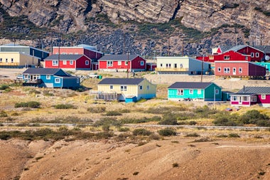
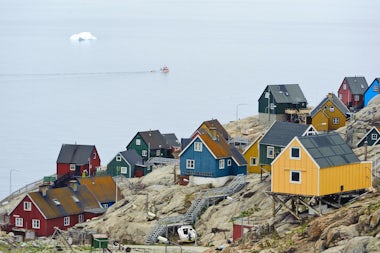
Kangerlussuaq (Danish: Søndre Strømfjord) is a settlement in western Greenland in the Qeqqata municipality, located at the head of a fjord of the same name, and just inside the Arctic Circle. The town lies between glacial-fed Qinnguata Kuussua river to the SE, fjord to the SW, and hills rising sharply to 400m to the north. Russell Glacier and the Greenland ice sheet lie about 22km further east. Read more about Kangerlussuaq, Greenland
|
| 2 |
Thursday, August 29, 2024 |
Sisimiut, Greenland |
12:00 AM |
12:00 AM |
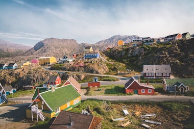
Sisimiut is a town in central-western Greenland, located on the coast of Davis Strait, approximately 320 km north of Nuuk, and about 42km inside the Artic Circle (April 2017). It is the administrative center of the region and the second-largest town in Greenland. As the northernmost year-round ice-free port in the country, it is an important shipping hub for outlying settlements. Read more about Sisimiut, Greenland
|
| 3 |
Friday, August 30, 2024 |
Saqqaq, Greenland |
12:00 AM |
12:00 AM |
Saqqaq is a village on the Nuussuaq Peninsula in the Quaasuitsup municipality of western Greenland, 380km north of the Arctic Circle (April 2017). The village of fewer than 200 is reached by sea only during summer and autumn. The village name means “the sunny side”, as it faces south. Read more about Saqqaq, Greenland
|
| 4 |
Saturday, August 31, 2024 |
Uummannaq, Greenland |
12:00 AM |
12:00 AM |
Uummannaq (Umanak) is a town in northwestern Greenland, located 590 km north of the Arctic Circle, on an island in the south-central arm of the fjord all sharing the same name. It is situated on a heartshaped island, hence its name which means 'heartlike place'. It is home to the country's most northerly ferry terminal. Read more about Uummannaq, Greenland
|
| 5 |
Sunday, September 1, 2024 |
Kullorsuaq, Greenland |
12:00 AM |
12:00 AM |
Kullorsuaq is a settlement in NW Greenland on Kullorsaq Island, Melville Bay, part of the larger Baffin Bay. The island is at the northern end of the vast Upernavik Archipelago that hugs the west coast of Greenland for a distance of 340 km. The first and official language is Kalaallisut or West Greenlandic, the colonial language being Danish. Read more about Kullorsuaq, Greenland
|
| 6 |
Monday, September 2, 2024 |
Savigsivik, Greenland |
12:00 AM |
12:00 AM |
Savigsivik is an Inuit settlement on an island off the far NW of Greenland, in Melville Bay, an extension of the larger Baffin Bay. It lies well within the Arctic Circle at 76 deg. North. Read more about Savigsivik, Greenland
|
| 7 |
Tuesday, September 3, 2024 |
Pond Inlet, Canada |
12:00 AM |
12:00 AM |
Pond Inlet is a small, modern, attractive Inuit community (population 1550) located on northern Baffin Island above the 72nd parallel. The town is particularly picturesque hamlet, surrounded by massive icecapped mountains, dozens of glaciers, ice floes and explorable ice caves. No wonder Pond Inlet is considered one of Canada's "jewels of the North". Read more about Pond Inlet, Canada
|
| 8 |
Wednesday, September 4, 2024 |
Savissivik |
|
|
| 9 |
Thursday, September 5, 2024 |
Beechey Island, Canada |
12:00 AM |
12:00 AM |
Beechey Island is located in the Wellington Channel of the Canadian Arctic Archipelago of Nunavut, Canada. It is separated from the southwest corner of Devon Island by Barrow Strait. The island is best known for being the place where members of Sir John Franklin’s party searched for the Northwest Passage in 1845-46. Read more about Beechey Island, Canada
|
| 9 |
Thursday, September 5, 2024 |
Beechey Island, Nunavut |
|
|
| 10 |
Friday, September 6, 2024 |
Fury Beach, Canada |
12:00 AM |
12:00 AM |
Fury Beach lies on the east coast of uninhabited Somerset Island in the Canadian Arctic Archipelago. It lies 176 km north of the Arctic Circle, and 180 south of the Northwest Passage shipping route that is becoming more frequented with explorer vessels due to the retreat of Arctic ice. The beach faces Prince Regent Inlet and Brodeur Peninsula of Baffin Island 74 km to the east. Read more about Fury Beach, Canada
|
| 11 |
Saturday, September 7, 2024 |
Bellot Strait, Nunavut, Canada |
12:00 AM |
12:00 AM |
Bellot Strait above the Arctic Circle is a 30 km passage, round 1 km wide, in the Canadian territory of Nunavut, separating Somerset Island on the north from the Boothia Peninsula on the south. The strait runs roughly east to west. Both sides of the strait rise steeply some 200m or so. Read more about Bellot Strait, Nunavut, Canada
|
| 11 |
Saturday, September 7, 2024 |
Sailing In The Bellot Strait |
|
|
| 12 |
Sunday, September 8, 2024 |
Gjoa Haven, Canada |
12:00 AM |
12:00 AM |
Gjoa Haven meaning "lots of fat", referring to the abundance of blubbery sea mammals in the nearby waters, is a hamlet in Nunavut, above the Arctic Circle. It is the only settlement on King William Island. The name Gjoa Haven was named after the ship of polar explorer Roal Amundsen. Read more about Gjoa Haven, Canada
|
| 13 |
Monday, September 9, 2024 |
At Sea |
|
|
| 14 |
Tuesday, September 10, 2024 |
Edinburgh Island, Canada |
12:00 AM |
12:00 AM |
Edinburgh Island is located within Coronation Gulf, south of Victoria Island, in the Kitikmeot Region, Nunavut, Canada. Between Coronation Gulf and the Canadian mainland, the Gulf is 55 km wide at this point. The island is 15 km by 9 km, rocky and barren, with highest point about 154 m above sea level. Read more about Edinburgh Island, Canada
|
| 15 |
Wednesday, September 11, 2024 |
Ulukhaktok, Canada |
12:00 AM |
12:00 AM |
Ulukhaktok (aka Ulukhaqtuuq, Holman) lies 460km north of the Arctic Circle on the west coast of Victoria Island, in the Inuvik Region of the Northwest Territories, Canada. The small hamlet has a population of around 500. Hunting, trapping, and fishing are major sources of income. Read more about Ulukhaktok, Canada
|
| 16 |
Thursday, September 12, 2024 |
Smoking Hills |
|
|
| 17 |
Friday, September 13, 2024 |
Smoking Hills, Canada |
12:00 AM |
12:00 AM |
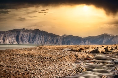
The Smoking Hills are dotted along a 30 km section of coastline on the east coast of Cape Bathurst in Canada’s NW Territories. The coast faces Franklin Bay, which in turn lies to the SE of the Beaufort Sea. The coastline, at 70 degrees north, is near the mouth of the Horton River. Read more about Smoking Hills, Canada
|
| 18 |
Saturday, September 14, 2024 |
Sailing In Beaufort Sea |
|
|
| 19 |
Sunday, September 15, 2024 |
Sailing In Beaufort Sea |
|
|
| 20 |
Monday, September 16, 2024 |
Sailing In Beaufort Sea |
|
|
| 21 |
Tuesday, September 17, 2024 |
Sailing In Beaufort Sea |
|
|
| 22 |
Wednesday, September 18, 2024 |
King Island, Alaska |
|
|
| 22 |
Wednesday, September 18, 2024 |
Nome, Alaska |
|
|
| 23 |
Thursday, September 19, 2024 |
Nome, USA |
8:00 AM |
Disembark |
Nome is a seaport used by freighters and cruise ships, located on the southern side of the Seward Peninsula in Norton Sound, Alaska, just 250km across from Siberian Russia. It was a small Inupiat Eskimo settlement until the discovery of gold in 1898 brought over 20,000 fortune seekers, but most left after 10 years, and today there are approximately 4000 residents with half being Native Americans. Interestingly, Nome is the finish line of the annual Iditarod Trail Sled Dog Race covering over 1680km across the wilderness from Anchorage. Read more about Nome, USA
|